36 more hours of rain chances!
6-10-24. 4:30pm. This update is brought to you by Jack Garrett and Phase II Fertilizer. Phase II, Inc. was founded in 1994 with a mission to Help Family Farmers & Ranchers Thrive. You can reach Jack at 361-275-4841.
What a great night and morning for rain over the western counties and the Hill Country! The upper-level low is now over New Mexico and will be trekking over north Texas over the next 36hrs. That feature along with a stationary front, will be the spark for more storms. We have a chance that some of the storms over west Texas will move through tonight, but the odds are not as good as last night. Scattered storms are possible tomorrow, but the next best chance for another complex of storms will be tomorrow late afternoon and evening as the upper-level low moves across Texas. As usual, some of these storms could become severe.
We heat up from Thursday through the weekend, then later next week we could see that change in the pattern I discussed a few days ago, allowing for daily sea-breeze storms and deep tropical moisture to flow into our area. More on that later.
Mark

This update is brought to you by Jack Garrett and Phase II Fertilizer. Phase II, Inc. was founded in 1994 with a mission to Help Family Farmers & Ranchers Thrive. You can reach Jack at 361-275-4841.

4pm radar...storms to our NW are moving SE and could move into the Hill Country later this evening.

An upper-level low over NE NM will be moving ESE over the next 36 hours.

Forecast surface map for tomorrow morning.
Click on images to see them larger. The latest severe weather graphic and potential for excessive rain today through Wednesday.


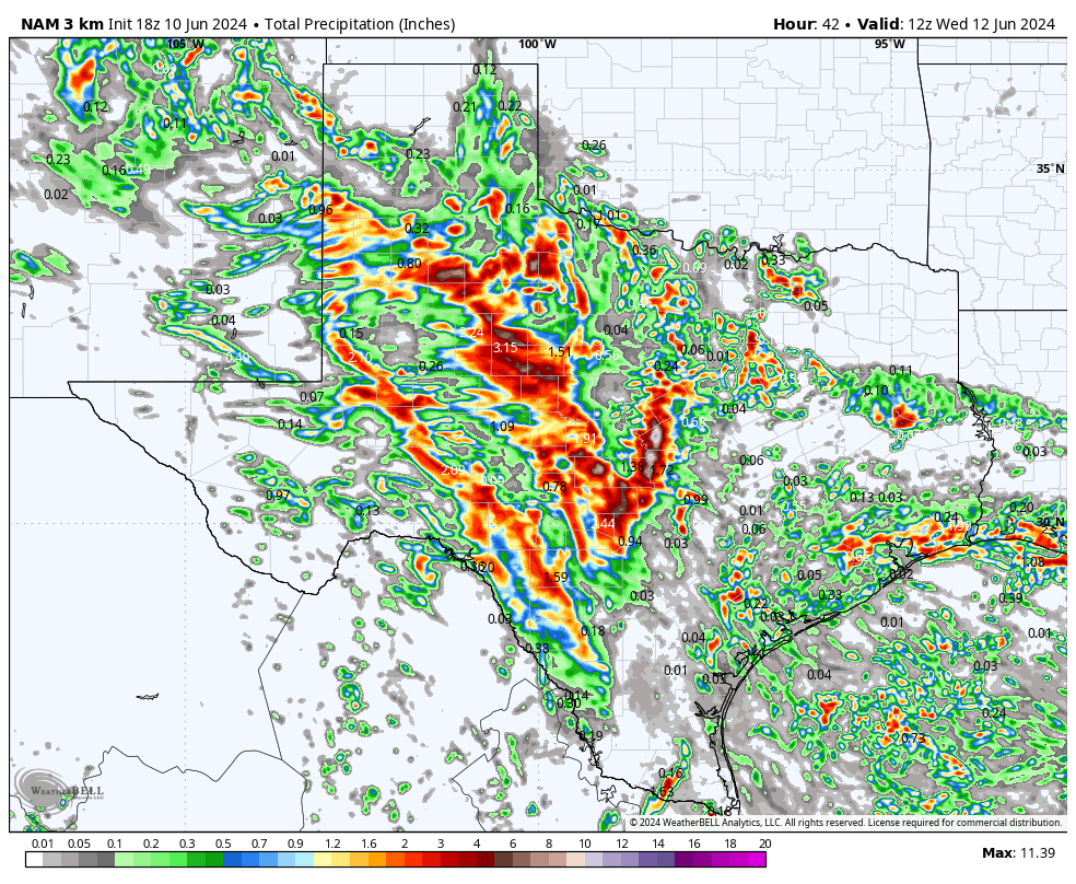
Click on images to see them larger. How much rain the latest models think will fall over the next 36 hours.