Less model waffling today!
1-17-25. 3:30pm. This update is brought to you by Dietz-McLean Optical. www.dmoptical.com
The latest NWS special weather statement arrived a few minutes ago and we are starting to see a clearer picture of what will happen next week. In a nutshell, it will be cold from Sunday-Thursday, with a chance for wintry precipitation on Monday night through Tuesday. While our lows will be in the 20’s and maybe a few teens in the Hill Country, it appears as of today, that we should warm up into the 30’s and 40’s during this event. The big “if” on the wintry precipitation is where will the precipitation actually fall. The latest models are keeping most of the moisture to the east of San Antonio.
Below are lots of model runs and all of the latest info from the San Antonio-Austin NWS. For those of you in south Texas, I have included models that show your area, since the ones from SA-Austin do not.
Mark

This update is brought to you by Dietz-McLean Optical. www.dmoptical.com
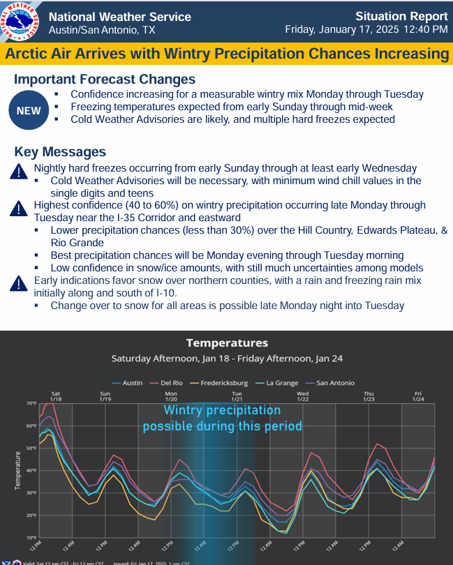
The latest greatest update from the SA-Austin NWS. Click on images to see them larger.


How much snow these models think will fall from Monday night through Tuesday of next week. Click on images to see them larger.


How much ice these models think will fall from Monday night through Tuesday of next week. Click on images to see them larger.


How much precipitation these models think will fall from Monday night through Tuesday of next week. Click on images to see them larger.


