The models are waffling!
1-3-25. 3:30pm. This update is brought to you by Dietz-McLean Optical. www.dmoptical.com
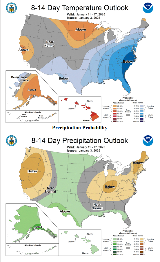
As of today, I can guarantee that next week will be cold and wet for most of south-central and south Texas. The big question is how cold and what type of precipitation will fall? Unfortunately, the models continue to waffle on how cold it will be and whether or not we will see snow, sleet or just cold rain. Given how models are often conservative on how cold it will be when we have arctic air in our forecast, I would continue to prepare for the possibility that we could see a couple of days late next week where we don’t get above freezing and the potential for wintery precipitation.
Here is what the SA-Austin NWS is saying about late next week in their latest update:
"While confidence is high for prolonged cold temperatures, confidence
on any wintry precipitation remains more challenging. A strong
upper-low will deepen and move over Baja Wednesday bringing
increased moisture to our area ahead of it. As mentioned in previous
discussions, there is a lot of small factors that will play into
exactly if or how much wintry precipitation will occur including
low level temperatures and QPF amounts. Ensemble guidance does seem
to be increasing chances for precipitation, particularly Thursday
and Friday, but will need to see how it overlaps with the sub-
freezing temperatures. The lowest precipitation chances are seen
Wednesday morning, and with limited moisture to work with any type
of precipitation would be light and brief as temperatures will rise
into the 40s most locations that afternoon. The best precipitation
potential is seen Thursday into Friday, and while there is currently
mostly rain in the forecast, this would be the main timeframe to
watch as further details are worked out in the coming days. Ensemble
members do continue to show a variety of scenarios within our area,
including some with multiple inches of snow or light icing, but we
could also just get some cold rain. As we are at the very end of the
forecast period for this potential, just stay tuned and keep up with
the evolving forecast."
The first round of cold air arrives Sunday afternoon and we could see temperatures fall from the 70’s to the 30’s by midnight! Look for the chance for freezes every morning next week (Monday-Saturday). We should see a booster shot of cold air on Wednesday, then an increasing chance for rain, snow or a mix, on Thursday and Friday.
Mark

This update is brought to you by Dietz-McLean Optical. www.dmoptical.com

We have waffling models on the menu for next week! AI by Mark!

How much snow these models are forecasting from Wednesday-Saturday of next week. Click on images to see them larger.


How much precipitation these models are forecasting from Wednesday-Saturday of next week. Click on images to see them larger.


How far below normal temperatures these models are forecasting from Wednesday-Saturday of next week. Click on images to see them larger.