An entertaining week ahead!
1-4-24. 4pm. This Update is brought to you by Davy Ranch Supply in Yorktown, TX. davyranchsupply.com
No matter how things pan out, this week will not be boring weather wise! For starters, after seeing highs in the 70’s on Sunday, temps will start dropping quickly in the afternoon behind our first cold front and by Monday morning, most locations in south-central Texas will see a freeze and south Texas will see temps in the 30’s and some 40’s.
I’ll let the NWS explain their thoughts on the rest of the week!
“By Tuesday night, an upper-level low pressure system over southern California is forecast to push to the southeast into Baja California and northwest Mexico. At the surface, overnight lows drop to the lower 20s across the Hill Country to mid and upper 20s and even lower 30s along the I-35 corridor. Dry and cold weather continues on Wednesday with highs in the 40s. By this time frame, the upper-level low pressure system mentioned above is likely moving over the northwest part of Mexico and then opens into a wave early Thursday morning while approaching central Mexico. This translates to slight chances for precipitation in a wintry mix potential for parts of the Rio Grande, southern Edwards Plateau and Hill Country including the Austin metro area while southerly winds return and overnight lows range from the upper 20s to lower 30s. Areas along and south of Highway 90 should see rain. Increased moisture continues to be pulled on Thursday as the upper short wave approaches South Central Texas and moves over on Thursday evening through Friday. During the day on Thursday, expect rain to be the main precipitation type. As temperatures drop to the freezing mark and below, the precipitation type likely to take many shapes including freezing rain, sleet and even snow.”
One thing to mention, this will not be a repeat of 2021, as we will likely see temperatures rebound into the 50’s by next weekend. In addition, I don’t see any widespread lows in the teens during this event, like we saw in 2021. With that said, I still think everyone in south-central Texas, especially in the Hill Country, needs to plan for the possibility that temps could stay below freezing for 24-48 hours from Thursday-Friday. I also think there is an increasing chance that there could be freezing rain with this event in the southern counties of south-central Texas and the northern counties of south Texas.
Mark

This Update is brought to you by Davy Ranch Supply in Yorktown, TX. davyranchsupply.com


An upper-level low is forecast to move from Baja to Texas from late Wednesday-Friday. This will give us a chance for precipitation during that time period.
The latest snow forecast from the four main models from Wednesday night through Friday of next week. Click on images to see them larger.


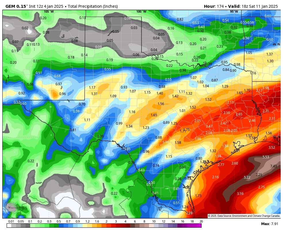
The latest precipitation forecast from the four main models from Wednesday night through Friday of next week. Click on images to see them larger.


The 850mb is considered the level in the atmosphere where if the temperature is below freezing, snow can form. The temps here are Celsius, so we need to see 0 or less for the chance for snow to form. Based on these forecasts, the best odds for snow will be on Wednesday evening and Thursday morning. The big question is whether there will be much moisture at that time. The odds for moisture increase Thursday-Friday. Click on images to see them larger.


