Here we go…
4-20-24. 3:15pm. This update is brought to you by Motor Carrier Safety Solutions in Laredo, TX. www.mcssinc.com
While very little rain is occurring as I post this update, there is a chance for heavy rain along the front this afternoon and evening.
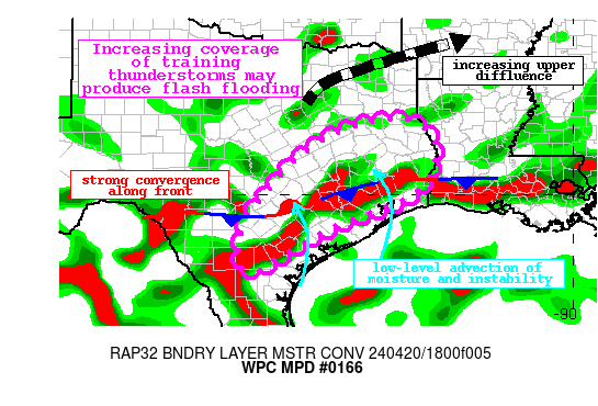
Mesoscale Precipitation Discussion 0166
NWS Weather Prediction Center College Park MD
404 PM EDT Sat Apr 20 2024
Areas affected...South-Central through Eastern Texas
Concerning...Heavy rainfall...Flash flooding possible
Valid 202003Z - 210200Z
Summary...Showers and thunderstorms expanding across portions of eastern Texas this afternoon will intensify through the evening and begin to train to the northeast. Rainfall rates of 1-2"/hr, possibly higher at times, are expected within this strengthening convection. This will result in 2-3" of rain with locally higher amounts up to 5", possibly resulting in instances of flash flooding.
Discussion...The regional radar mosaic this afternoon indicates a
rapid expansion of showers and thunderstorms across eastern Texas from near the LA/TX border southwest through portions of
south-central Texas. Rainfall rates within this fresh convection
have been estimated via local WSR-88Ds to be up to 1"/hr already,
with regional mesonet observations measuring as much as 1/3 of an inch in 20 minutes.

This update is brought to you by Motor Carrier Safety Solutions in Laredo, TX. www.mcssinc.com