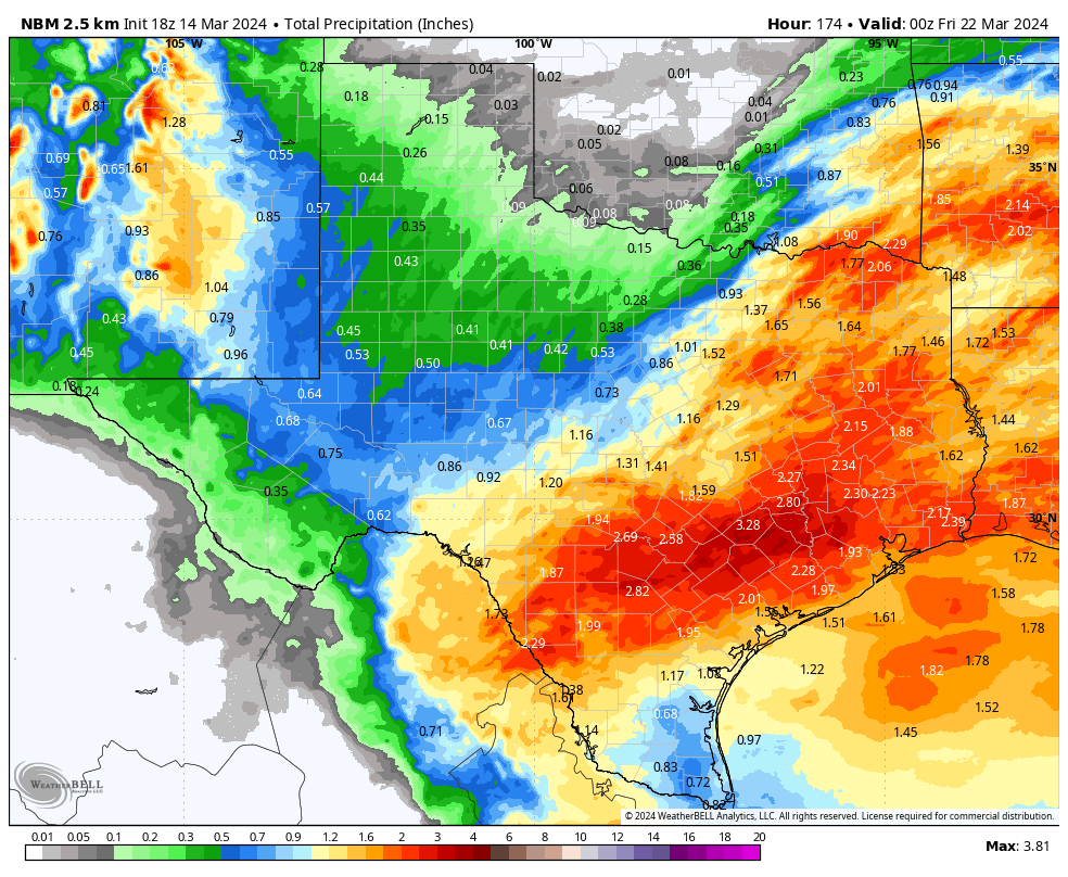
Widespread rain is on the way!
3-14-24 5:30pm. This update is brought to you by Motor Carrier Safety Solutions in Laredo, TX. www.mcssinc.com
As forecast, our cut-off low has formed in SE California this afternoon and it will be a key player in our upcoming six-day rain event! As I mentioned yesterday, it won’t rain the entire six days, but we will have decent rain odds almost every day through next Thursday. The best odds for heavier rain will be Friday and Saturday as our next cool front goes stationary around San Antonio tomorrow afternoon, allowing for showers and thunderstorms to form in that area. There is a risk of severe storms on Friday in a relatively small zone that includes Austin and San Antonio. The biggest threat will be hail and high winds, but tornadoes are not out of the picture. On Saturday, the front pushes further south, but several disturbances will keep rain odds ramped up through Sunday. This will be a convective system, so there will be some rain lottery winners with totals during the period of over 4 inches, but I think most of you in south-central and northern counties of south Texas will see at least 1-2 inches of rain by next Thursday.
With the cut-off low still to our west next week, we will continue to see chances for rain through Thursday, when the low finally gets absorbed into a trough and moves out into the plains. As long as the low sits to our west, we will see lots of Pacific moisture being drawn into the upper levels from the SW and disturbances kicking off showers and thunderstorms.
This update is brought to you by Motor Carrier Safety Solutions in Laredo, TX. www.mcssinc.com
Our cut-off low was formed today in SE California! It will stay in that area for the next several days, causing our upper-level winds to stay out of the SW, tapping into Pacific moisture.
A cool front will go stationary around San Antonio tomorrow afternoon, leading to the potential for severe storms.
There will be a slight risk for severe storms in the yellow zone tomorrow. Hail and high winds will be the main threat.
Where there is a chance for excessive rain tomorrow.
Where there is a chance for excessive rain on Saturday.
Below are the latest model runs for precipitation totals from tomorrow through next Thursday.


