My Pagosa Springs, CO 2024-25 Winter Forecast!
10-5-24: It’s time to stick my neck out again after doing very well this past monsoon season! Can I go two for two this year or will my winter forecast be a bust? Time will tell…
OK, as I am typing this post, it is 75 degrees outside and certainly not feeling like it should in early October! It has been mainly dry over the past week with daytime highs 5-10 degrees above average. A high pressure is locked over much of the country and it seems like it doesn’t want to go away anytime soon.
Fortunately, as we move through October, that high will break apart and we will start seeing some early storms move through our area. While I still see a fairly dry October ahead, with total precipitation at about half of our normal 2.29 inches, I do think we will be back on track, precipitation wise, in November. For the winter, I see storms happening fairly frequently with the usual dry weeks thrown in. As we progress into late winter and early spring, we could see an increase in activity as our weak La Niña transitions into a neutral pattern.
Here are some thoughts and details:
A typical La Niña means a drier and warmer winter for southern Colorado as seen in this chart from the NWS.
This will be a weaker and short lived La Niña, similar to our 2016-2017 and 2023-2024 winters. As you can see by this chart of Wolf Creek snow totals, those two years dropped above average snow.
Ocean temps continue to be above normal for much of the northern Pacific, even though equatorial temperatures have dropped. This stored energy will allow for more moisture to move into the west as storms move through, leading to higher snow totals. While this will be great for Wolf Creek, I do worry about all of you living in elevations under 7500 feet. If temperatures end up warmer than normal (which I think they will), you could see quite a few slushy storms with a rain-snow combo. Snow blowing might not be much fun this winter!
So, with all of this in mind, I am predicting a snowier than average winter and warmer than average temperatures…not forgetting that our winter temperatures are pretty darn cold, even if they end up being above average! My best guess for Wolf Creek ski area is 425 inches for the season.

A typical La Niña winter pattern.

La Niña conditions are forecast to start winding down by early next year.

La Niña winters that are similar to the one coming up.

Snowfall totals from recent weak La Niña winters as compared with average snowfall at Wolf Creek Ski area.

La Niña is showing up along the equator, but sea surface temps are very warm in the northern Pacific.

As usual, the CPC goes with typical La Niña data for their winter forecasts.

As usual, the CPC goes with typical La Niña data for their winter forecasts.

As usual, the CPC goes with typical La Niña data for their winter forecasts.
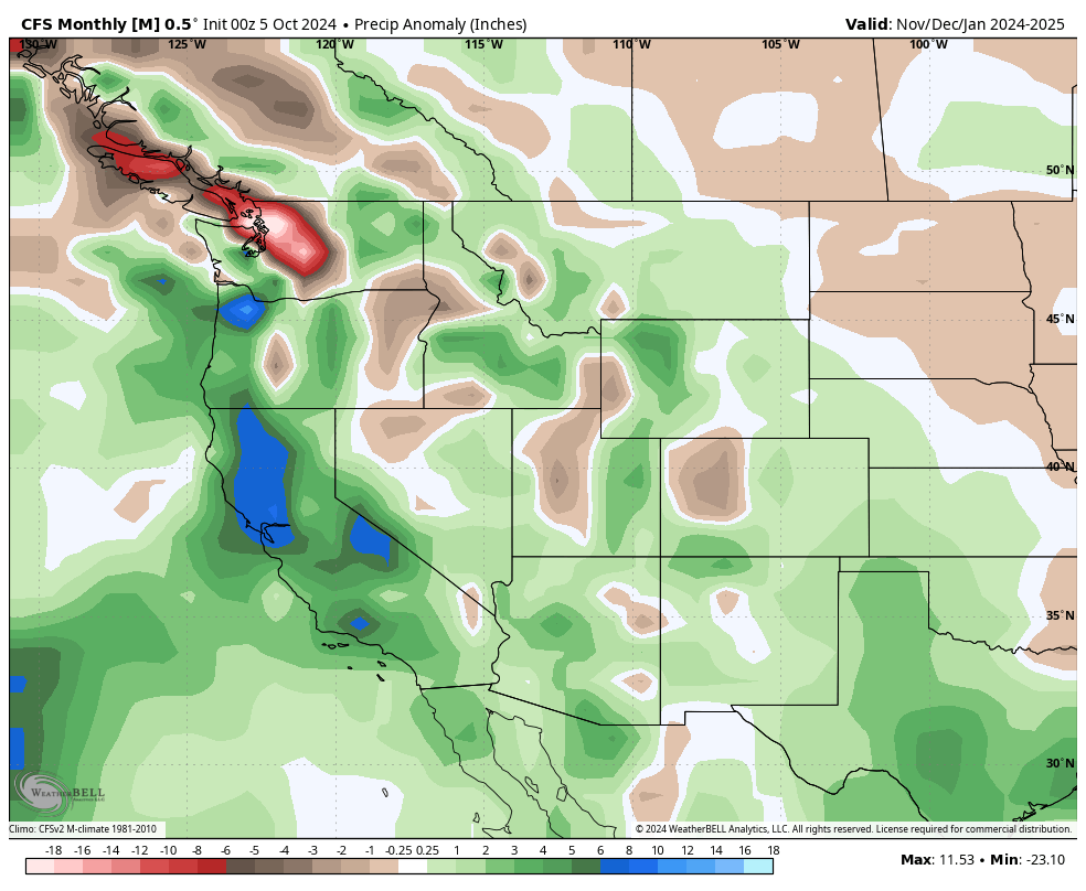
The CFS seasonal model agrees with my prediction.

Frosty is happy with this forecast!