Some nice bonus rain yesterday!
7-7-24. 11am. This Tropical Update and Rainfall Roundup Combo is brought to you by Dietz-McLean Optical. www.dmoptical.com
Before we talk about Beryl, let's talk about some great bonus rain that fell across south-central Texas yesterday! While I know that many of you missed the rain, (including my weather station in NW Bexar County), there were some impressive rain totals in Real, Gillespie, Blanco, Travis and Guadalupe counties. I have posted some rainfall graphics below and here is a link from the SA-Austin NWS of their totals across south-central Texas:
https://mesonet.agron.iastate.edu/wx/afos/p.php?pil=PNSEWX&e=202407071455
Now on to Beryl...
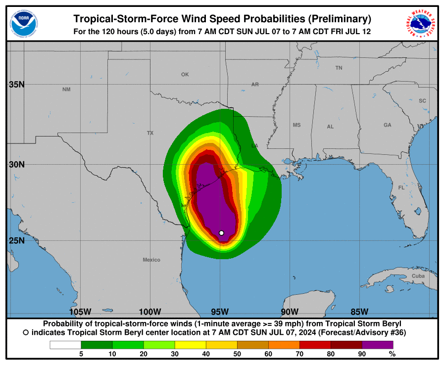
The good news is that we can all watch her on radar to see if she has any tricks up her sleeves as she approaches the Texas shoreline today. The NHC still thinks Beryl will hit between Palacios and Matagorda tomorrow morning as a Cat 1 hurricane, but they are concerned that she could grow to a Cat 2, so if you live along the coast don't take Beryl lightly! If this track holds, then Beryl will have very little impact on south-central Texas except for the far eastern counties. I'm hoping there could be some wrap-around showers and some thunderstorms over the next couple of days and with deep tropical moisture in place, we could see some poppers as well.
As I have been mentioning, our rare July cool front will act as a wall and keep Beryl moving to the NE when it makes landfall. I have included a surface map for Tuesday below. As of this post time, there are no future storms in the 7-day NHC forecast, so once Berly moves away, we are back to our regular scheduled summer programing.
As always, please make sure you have emergency warning apps on your device switched on or you have a NOAA weather radio turned on to receive warnings and evacuation updates. I am a one-man band, and I can't keep up with every location in south-central and south Texas.
Good luck to all of you living near the coast...I hope Beryl doesn't strengthen much in the next 24 hours!
Mark

This Tropical Update and Rainfall Roundup Combo is brought to you by Dietz-McLean Optical. www.dmoptical.com
Click on images to see them larger. 24hr rainfall totals from the NWS and COCORAHS.


10am radar update shows Beryl clearly.


Close-up track for Beryl.

Zoomed in track for Beryl on Monday morning.

Forecast surface map for Monday, shows Beryl being pushed to the NE by a cool front.
Click on images to see them larger. The latest watches, warnings and rainfall updates on Beryl.


Click on images to see them larger. The latest model runs for rainfall totals from Beryl.


