Still a lot of questions in regard to Beryl!
7-5-24. 2pm. This Tropical Update is brought to you by Jack Garrett and Phase II Fertilizer. Phase II, Inc. was founded in 1994 with a mission to Help Family Farmers & Ranchers Thrive. You can reach Jack at 361-275-4841.
Let's talk about the "Cone of Uncertainty"! As you can see in the latest 1pm NHC update, Beryl still has a huge cone of uncertainty even though we are only 3 days from potential landfall. This coned area represents where the storm could potentially track. While the NHC more often than not, hits pretty close to their forecast track, this storm is very complicated, because its eventual strength and how strong the trough is in the plains, will determine where it goes. As of this morning, the thinking is that the trough (rare in the summer) will be strong enough to push the eastern side of the high pressure further east, steering the storm further east. The latest model runs are supporting that. If Beryl stays pretty weak, it will be less prone to being steered by the trough and more likely to move more NW. As far as how strong Beryl grows, that too, is still hard to forecast...it's been downgraded to a tropical storm after being ripped up by windshear yesterday and the Yucatan Peninsula today.
I just looked at the latest surface map for Tuesday morning and realized we have yet another variable! The NWS is showing the cool front dropping down to a Del Rio to College Station line with Beryl around San Antonio. If the front goes stationary (forecast) then we could see the scenario of the Canadian model play out.
From the NHC: Users are reminded that the average NHC track error at day 3 is around 100 miles, and it remains too soon to pinpoint where the greatest impacts will be. However, watches for portions of northeastern Mexico and South Texas will likely be required later today.
While I know many of you are giving up on rainfall from this storm, there is an additional variable that the latest Canadian model run has found...what if this storm moves north, then goes stationary? Check out the rainfall forecast from the Canadian model. This is possible if the storm moves north, then bumps into high pressure in central Texas.
For those of you who live along the coast, please check in with your local NWS forecasts and the NHC for updates every few hours. At this time, I really can't say where Beryl will end up. It could move onshore from South Padre Island to Beaumont! I can say that if you are planning on going to any of the coasts this week, you may want to re-think those plans. Even if the storm doesn't hit your particular beach, there will be lots of rain, wind, storm surge and rip tides.
Mark

This Tropical Update is brought to you by Jack Garrett and Phase II Fertilizer. Phase II, Inc. was founded in 1994 with a mission to Help Family Farmers & Ranchers Thrive. You can reach Jack at 361-275-4841.

The latest info and tracking for Beryl. Notice how large the cone of uncertainty (dotted lines) is!

Close-up of the latest track from the NHC for Beryl.

Yet another variable! This latest surface map from the NWS shows a front going as far south as a Del Rio to College Station line. This would certainly also add another variable to the forecast.

The latest spaghetti model runs for Beryl.

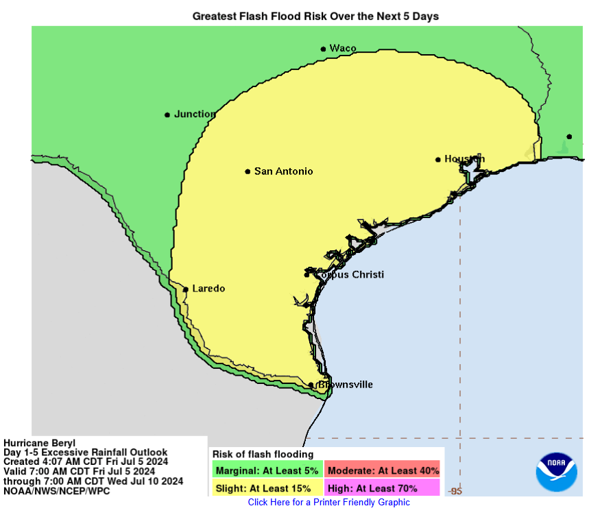
Click on images to see them larger. How much rain these models are forecasting from Beryl next week.


