Rain chances continue through Sunday…
7-26-24. 2pm. This Update is brought to you by Davy Ranch Supply in Yorktown, TX. davyranchsupply.com
Thanks to our trough, that will stick around through Sunday, we continue to see scattered storms in our area. Storms have been heavier and less scattered to the SE and East of San Antonio today, with the NWS issuing a Mesoscale Precipitation Discussion. The graphics are below along with the info.
As seen on the latest water vapor imagery below, the best odds for rain today will be in the blue sections of the imagery, representing moisture aloft, with yellow, being drier air. This trough (the dividing area for blue and yellow) will stay pretty close to this position today and tomorrow. On Sunday it will move further NW, increasing rain odds for the western counties, just before high pressure moves in on Monday, drying us out.
If you have had or are getting some rain today, let us know how much and where!
Mark

This Update is brought to you by Davy Ranch Supply in Yorktown, TX. davyranchsupply.com

1:45pm radar imagery.
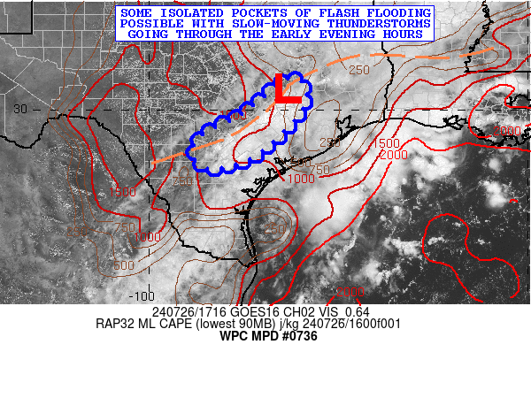
SUMMARY...Some isolated pockets of flash flooding possible with
slow-moving thunderstorms going through the early evening hours
across south-central to southeast TX.
Some of the additional convective clusters will be capable of
producing some 1 to 2 inch/hour rainfall rates, and with concerns
over slow cell-motions, some additional rainfall totals of 2 to 4
inches may be possible. This coupled with locally sensitive
antecedent conditions will support a threat for at least isolated
areas of flash flooding.

Current location of our trough. Areas in yellow represent drier air aloft and blue tones represent moist air aloft and better odds for storms.
Click on images to see them larger. How much rain these models are predicting between today and Sunday.


